
Gyumri
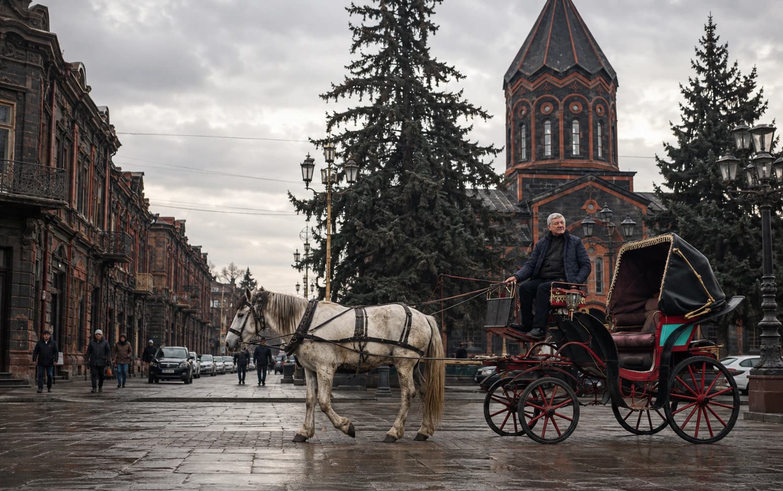
Gyumri is the one place in Armenia where the nineteenth century is still the everyday building stock, not a set of monuments. Walk out of the centre in most directions and the streets are lined with one- and two-storey houses of dark volcanic stone. Masons cut and carved them, and their descendants are still at work; the grid they stand on was drawn by a Russian imperial surveyor. That is unusual anywhere in the region, and it is why this article exists. Armat's other Places are single buildings, enclosures and landscapes. This one is a whole city, which needs explaining rather than listing. The city has also had four official names in under two centuries: Kumayri, Alexandropol, Leninakan and Gyumri, and each change was made by a different state. Most of what there is to understand about the place comes down to how those names, that stone and the earthquake of 1988 fit together.
- Author
- Armat Editorial Team
- Updated
- Reading time
- 26 min read
In brief
Gyumri is Armenia's second city and the administrative centre of Shirak Province, on a high plain in the north-west of the country. The settlement is old, but the city is not. It grew after the Russian Empire annexed the region, took the name Alexandropol in 1837, gained city status in 1840, and became the largest town in Russian-ruled Eastern Armenia. It was renamed Leninakan in 1924 and Gyumri in 1992. Its historic core, protected since 1980 as the Kumayri reserve, is the largest surviving nineteenth-century urban fabric in the country, built of local volcanic tuff by local masons. The 1988 earthquake destroyed much of the modern city around that core, and rebuilding took decades.
Key facts
- Kind of place
- A city — the second of the Republic of Armenia, and the centre of Shirak Province
- Where
- The Shirak plain in the north-west, roughly 120 kilometres from Yerevan and close to the closed border with Turkey
- Height
- About 1500 metres above sea level. The figure usually printed is 1509 metres, but the city is large enough that any single number is an approximation
- Names
- Kumayri; Alexandropol from 1837; Leninakan from 1924; Kumayri again in 1990; Gyumri from 1992
- Historic core
- The Kumayri reserve, declared in 1980 and covering roughly a fifth of the city's area
- Population
- 112 301 recorded at the census of October 2022; a dated count, not a permanent figure
Where Gyumri is, and which Gyumri is meant
Gyumri stands on the Shirak plain in the north-west of the Republic of Armenia, about 120 kilometres from Yerevan by road and a short distance from the closed border with Turkey. The plain is high, open and treeless. The city sits at around 1500 metres, higher than most European capitals, and the plain is ringed at a distance by the Aragats massif to the south-east, the Shirak range to the north and the Akhuryan river valley to the west. The wind and the winters are harsher here than on the Ararat plain, and both show in what the city is built of and how.
The sources use the names Gyumri and Shirak for four different things, and mixing them up is the most common way a statement about this city goes wrong. There is the city itself. There is the urban community, the municipal unit that runs it. There is Shirak Province, the marz of which the city is the centre, which reaches north to the border with Georgia. And there is the historic core, the old town inside the modern city, with its own legal boundary and its own name. A population, area or elevation given for one of these does not apply to the others, so this article says each time which one it means.
The province matters here for locating the city and little else. Gyumri is the marz centre of Shirak, so it is the seat of the regional administration, with the courts, hospitals and offices a provincial capital carries. The rest of this article is about the city and its core.
Kumayri, Alexandropol, Leninakan, Gyumri
The history of the city's names is well documented and still easy to get wrong. Four different authorities made the changes for four different reasons, yet they are often strung into one tidy line as if they were the same kind of event.
The oldest name is Kumayri, and Gyumri is generally taken to be the same word worn down by use, not a separate name. The settlement kept it into the nineteenth century, and under that name it entered the Russian Empire. Russian forces occupied the region in the war that began in 1804, and Persia formally ceded it in 1813.
Alexandropol was the first change made by a state. Emperor Nicholas I visited in 1837, and the town was renamed after Empress Alexandra Feodorovna. Three years later, in 1840, it was granted city status and made the centre of a district. These were two separate acts, and this article keeps them apart, because a great deal of writing about Gyumri wrongly treats 1837 as the year it became a city. In English the name is spelled both Alexandropol and Alexandrapol. This archive uses Alexandropol throughout; the other form is a different transliteration of the same place.
Leninakan was the Soviet change. The city was renamed in 1924, the year Lenin died, and kept that name for most of the twentieth century. So when the earthquake struck in 1988, the city on news bulletins around the world was called Leninakan. Readers who know the disaster by that name are thinking of the same place.
The last two changes came with the end of the Soviet Union, at two different moments. The Soviet name was dropped in 1990 in favour of the older Kumayri, and the present name, Gyumri, was adopted in 1992, after independence. That makes four names and five changes of usage, and none of them came from the inhabitants gradually deciding to call the place something else.
What stood here before the nineteenth century
Everything above concerns a city about two hundred years old. The ground beneath it is much older. Describing that past accurately means keeping four claims apart, which popular writing constantly merges: archaeological occupation of the site, a written reference to a place of this name, continuous settlement, and the existence of a city.
Archaeology on and around the site shows occupation reaching back into prehistory. That is unremarkable for a well-watered plain in this highland, and the same is true of most of Armenia. Kumayri is named in early medieval Armenian narrative sources, in connection with the risings against Arab rule in the eighth century. This shows that a settlement of that name existed at that date, and nothing more. Claims that link the name to an Urartian royal inscription are inferences drawn from campaign accounts that name other places in this district. They are a different kind of evidence from a text that actually says Kumayri.
So the claim this article can support is a modest one. People lived here for a very long time. The settlement was substantial enough to be named in medieval sources. It was still village-sized in the early nineteenth century, when the events in the next section turned it into a city within two generations. Gyumri is not a continuously urban site of great antiquity, and this archive says so plainly instead of reaching for a round number of millennia.
The Russian century, and how a village became a city
The transformation began with a border. When the Russian Empire took this region from Persia and then fought the Ottoman Empire just to the west, Kumayri stopped being an inland village. It became a frontier town on the empire's edge, with a garrison, a customs post and a road to supply. Everything that followed grew out of that.
The first change was in the population. The war of 1828 to 1829 ended with a large movement of Armenians from Ottoman territory into the Russian Caucasus, and Kumayri took in a substantial share of them. Families from Kars, Erzurum and the surrounding country settled in and beside the existing town. A place once counted in hundreds of households was suddenly counted in thousands. Those newcomers, with the crafts and trade connections they brought, built most of what a visitor sees today.
The second change was military. An imperial order of 1834 started the construction of a fortress above the town, finished over roughly the following decade. The town was renamed Alexandropol in 1837 and given city status in 1840. From then on Alexandropol was a garrison city, and the garrison shaped its economy. An army in permanent residence buys bread, leather, iron and cloth, and needs carting and building work. That is a large part of why the crafts described further on grew as they did.
The third change was the street plan. A city laid out under Russian imperial administration in this period got a surveyor's grid: straight streets crossing at right angles, rectangular blocks and a central square. That grid is still the plan of the old town and the frame for everything else in the city. As the next section explains, local builders then filled it in a way that no plan had specified.
The fourth change was the railway. The line from Tiflis reached Alexandropol in 1899 and was extended west to Kars in the same year, and a branch ran south to Yerevan by 1902. This turned a garrison and market town into a junction. For the rest of the imperial period Alexandropol was the largest city of Russian-ruled Eastern Armenia, larger than Yerevan, and its workshops and warehouses served a whole region, not just a district.
The twentieth century arrived early and hard. Turkish nationalist forces captured Alexandropol in the autumn of 1920, and the treaty signed in the city as the first Republic of Armenia was collapsing bears its name. The state university, founded by decree in 1919, opened in Alexandropol at the start of 1920 before moving to Yerevan. By the time the city entered the Soviet period as Leninakan, it had already been Armenia's second city for a lifetime, and it stayed that way.
Black tuff, and what the city is actually built of
Gyumri is described everywhere as a city of black tuff, and the phrase only helps once the geology is explained. Tuff is a rock made of compacted volcanic ash, and the Armenian highland is full of it because the highland is volcanic. It is light, can be worked with hand tools when freshly quarried, and hardens once exposed to the air. Its colour depends on what was in the ash. So Armenian towns are built of pink, orange and grey tuff and, in the quarries of this district, a dark grey to black tuff. Gyumri looks the way it does because its masons had that stone at hand.
The label should not be stretched too far. Not every historic building in Gyumri is black. Local builders also used red and reddish tuff, sometimes in the same façade as the dark stone, and the deliberate contrast between the two is part of the local style, not an accident. Describing the city as uniformly black is a photographer's impression, not an accurate account of its buildings.
The old town holds together through a shared way of building more than through a shared colour. The buildings are load-bearing cut stone, one or two storeys high, set on the street line with a door and windows on the front and living space arranged around an inner courtyard. The stone is dressed, and doorways, window surrounds, cornices and balconies carry carving cut by hand: restrained on a modest house, elaborate on a merchant's. A study of the city's vernacular architecture calls the result freedom within the grid. Local craftsmen filled an imperial street layout using their own repertoire, which is why the old town reads as one place and not as a collection of separate designs.
The last element is iron. Gates, window grilles, balcony railings, door fittings and brackets are all forged, which is why the section on blacksmithing below is as much about architecture as about a craft. Two trades in the same town made the stone and the iron for the same buildings, and Gyumri's look is what they produced together.
The historic core, and how its monuments are counted
The old town has a legal identity. In 1980, under the Armenian SSR, the historic core was declared a protected reserve under the older form of the city's name: the Kumayri historical and cultural museum-reserve. Its stated purpose was to stop the low-rise historic streets from being demolished for new construction. It covers roughly a fifth of the city's area, a very large share for a historic core. In 1998 it was transferred from the state to the city as municipal property. So it is run by the community, not by the national museum-reserve service that manages Garni or Metsamor, which explains why the reserve is often missing from national heritage listings.
The number of monuments needs careful handling. Published figures for the Kumayri reserve range from about a thousand to eighteen hundred, and they are printed without saying what is being counted, inside which boundary, or when. Each of those three questions changes the answer. A count of listed monuments is not a count of historic buildings, a count inside the reserve is not a count for the whole city, and a count made in 1980 is not a count made now.
A reliable figure does exist, and it comes from law rather than promotion. The Government of the Republic of Armenia approved the State List of immovable historical and cultural monuments of Shirak Province by a decision of 2004. The section of that list covering the city of Gyumri has roughly a thousand numbered entries, some with sub-items. That count comes with a real boundary and a real date, and this archive is willing to quote it because the three questions above have answers.
The condition of the buildings is a separate matter from their legal status, and it is not good everywhere. The reserve survived the earthquake far better than the Soviet districts around it, for reasons given in the section on the earthquake below. But a protected quarter of low-rise stone houses in a city with a long housing shortage is under constant pressure, and unregulated changes to façades are a documented and continuing problem. Protection here is an ongoing process, not something done once and finished.
Blacksmithing, and what UNESCO actually inscribed
Alexandropol was a city of trades. A frontier city with a garrison, a market and a railhead needed metal, stone, leather, wood and cloth worked locally, and it organised these trades into guilds. The wealth and self-image of the nineteenth-century town came from that craft economy, not from any single industry. Of all those trades, blacksmithing is the one that has survived into the present as a living urban practice.
The smiths of Gyumri make architectural pieces above all: window grilles, gates, railings, doors and door fittings, along with candlesticks and lamps. That links the craft directly to the streets described above. The ironwork on a Gyumri house is part of the architecture, not decoration added to it, and the two trades grew up serving the same buildings. Skills were passed down within families, and some of today's smiths are the fifth or sixth generation of their own workshop. Now the craft is also taught at the city's art academy and craft college.
In 2023 UNESCO inscribed the tradition of blacksmithing in Gyumri on the Representative List of the Intangible Cultural Heritage of Humanity, on Armenia's nomination, as element number 01967. The exact wording matters. What was inscribed is a living practice: the knowledge, the skills and the passing on of them. And the list it went onto is the intangible heritage list, a separate instrument from the World Heritage Convention, with a different purpose and different legal effects.
Gyumri is not a World Heritage Site, and no part of it is inscribed as a World Heritage property. What UNESCO lists is the city's blacksmithing tradition, as an element on the Representative List of the Intangible Cultural Heritage of Humanity. The two statements sound alike but mean entirely different things. Material about the city confuses them often enough that this article spells out the difference instead of trusting readers to make it.
One more UNESCO link is real and usually missed: Gyumri joined the UNESCO Global Network of Learning Cities in 2016. That is a network for cooperation between cities on lifelong learning, and it is neither a heritage designation nor a claim about the city's buildings. Gyumri is not a UNESCO Creative City, and as of 2025 no city in Armenia belonged to that network.
Buildings that carry the story
Four buildings are worth naming, not as sights but because each stands for one part of the story above. None of their histories is told here, because each has more of one than a paragraph can hold.
The Church of the Holy Saviour, Amenaprkich, is the nineteenth-century town's own monument. It was begun in 1858, finished around 1872 and consecrated in 1873. The newcomers built it with their own money in Alexandropol's boom years: a large church raised by a town that had been a village within living memory. It was badly damaged in 1988, its restoration ran for decades, and it was reconsecrated in December 2024.
The Cathedral of the Holy Mother of God, known as Yot Verk, the Seven Wounds, is the other great church of the same period and the same community, and it stands on the central square. It was also damaged in 1988, but repaired earlier. Together the two churches give that square its character.
The Black Fortress, Sev Berd, belongs to a different story and should stay in it. It is a Russian imperial military work, ordered in 1834 and built over the following years on high ground above the town. It was a frontier fortification from the same imperial moment as the naming of Alexandropol. It is not a medieval Armenian castle, and it is not the origin of the town. This article makes no claim about any fighting over it or from it, because the popular accounts of that are not supported by anything citable.
The last of the four is not a monument at all: the museum of urban life, housed in a merchant family's town house of the 1870s. A city whose historic importance is domestic and commercial rather than monumental is properly represented by a house, and that is what the museum is there for.
7 December 1988
On 7 December 1988 an earthquake struck northern Armenia. Its epicentre was near the town of Spitak, some tens of kilometres east of the city then called Leninakan. Scientific studies put the main shock at a moment magnitude of about 6.8, on a reverse fault that broke the surface for something like 13 kilometres, with aftershocks confined to the upper crust. It is the defining event in the modern history of this city and of this province.
The damage in Leninakan was severe, and it hit one kind of building hardest. Engineering studies after the event found that the multi-storey precast-concrete apartment blocks of the Soviet period performed catastrophically. They failed at the joints between prefabricated parts, not in the parts themselves. A second finding is specific to this city. Leninakan stands on soft sediment, and seismologists concluded that it amplified the shaking in exactly the range of periods that matters most for buildings of that height. Two problems came together: a building type with no reserve of ductility, and ground that magnified the very motion it could not withstand. That is why the same earthquake did far more damage here than in the other large city it struck.
The other side of that finding deserves attention. The low-rise stone buildings of the historic core came through the earthquake much better than the tall modern blocks around them, and that is largely why the old town survives today. The difference lies in construction: low, heavy, load-bearing masonry against tall precast frames on soft ground. It does not mean that the past built better than the present. It is also why the Kumayri reserve still exists as real buildings, and not only as a legal boundary.
The human cost is covered here in one paragraph and no more. The earthquake killed tens of thousands of people across the affected region and left several hundred thousand without homes. Published figures for the region are estimates spanning a wide range, and figures for this city in particular are often quoted without saying what they measure. This archive gives no precise death toll for Gyumri, because it has found no authoritative source that defines one, and a number repeated without its basis is a rhetorical device, not evidence. What matters for everything that follows is that a city of well over two hundred thousand people lost a large part of its housing in a single morning, and a large part of its population in the months that followed.
Reconstruction, and why it is written in the present tense
The Soviet authorities promised to rebuild the city within two years. Several thousand apartments were finished in the three years the Soviet Union had left, and then the state that made the promise ceased to exist. Independent Armenia faced economic collapse, a blockade, an energy crisis and a war. Reconstruction did not stop, but it changed from a centrally funded programme into a long series of state, diaspora and international projects.
The most visible result was the domik: a temporary shelter, often a converted metal container, put up in the winter after the earthquake to serve for two or three years. Households were still living in them decades later. The phased clearance of this temporary housing, through state programmes and charitable building, continued well into the present century. To say that Gyumri was rebuilt is true of the city as a whole and untrue for a great many individual households, and an honest account needs both halves.
Heritage restoration moved just as slowly. The Church of the Holy Saviour was under restoration for the better part of thirty years and was reconsecrated in December 2024. That date is a useful marker for anyone asking when the earthquake stopped being part of the city's present, because in some respects that happened only recently.
The population figures tell the same story more coldly than any description. The census of 2001 counted 150 917 people in Gyumri, that of 2011 counted 121 976, and that of October 2022 counted 112 301, against a pre-earthquake city of well over two hundred thousand. The city has not recovered its size, and the decline continued throughout the reconstruction.
A note on counting a living city
The figure above needs its basis stated, because numbers like this get copied for a decade after they stop being true. Armenia's census reports two populations: a permanent (de jure) count of people who usually live in the country, and a current (de facto) count of people actually present when the count is made. Nationally, the two differed by a quarter of a million people in 2022. A city figure given without its date or basis is therefore weaker than it looks. A reader who finds three different numbers for Gyumri in three sources is usually looking at three different measurements, not at a mistake.
The same caution applies to the annual estimates published between censuses. They roll the previous census forward and form a separate series from the census itself. This article gives census counts with their dates and does not present any population in its prose as a permanent property of the place. In a city whose defining modern experience is the loss of close to half its people, the trend is what matters, and any single number is only a snapshot of it.
Cultural capital, city of crafts, city of humour
Three labels follow Gyumri everywhere. Each makes a different kind of claim, so this section examines them instead of repeating them.
Cultural capital has an official version and a popular version, and they are not the same. Gyumri holds no standing national title as Armenia's cultural capital. It was named cultural capital of the Commonwealth of Independent States for the year 2013, an annual honour that goes to a different city each year, not a permanent status. The popular usage is much older than the award and rests on something real: a city with its own theatre, its own school of painters, a long musical life and an unusually close link with well-known writers and performers. Still, it is a reputation, and this archive describes it as one.
City of crafts is the most defensible of the three, because it describes an economy that can be documented: the guild trades of nineteenth-century Alexandropol, the smiths still at work, and the ironwork and stonework on the buildings themselves. It is a statement about the city's history, not a slogan, and the sections above on the stone and on blacksmithing are what it rests on.
City of humour is a real cultural convention, and the one most easily mishandled. Gyumri has a long-standing reputation in Armenia for a particular kind of wit, carried by named local figures who are the heroes of a body of anecdotes. That reputation is old, widely shared and worth recording. But it does not describe the character of the people who live there. A reputation can belong to a place; personality traits do not belong to a population, and an article that treated them as if they did would be dealing in stereotype, not cultural history.
Behind the labels lies a plainer fact. This is the city where Avetik Isahakyan was born and raised, and where Armen Tigranian's opera Anush was first staged in 1912. It was the first Armenian opera built on folk melody, and it premiered in a provincial city because that city had the musicians and the audience for it. That is what a cultural capital looks like from the inside, without any slogan.
Important dates
1804
Russian forces occupy the Shirak district during the war with Persia, and the Treaty of Gulistan formally cedes the region to the Russian Empire in 1813. Kumayri passes from one empire's frontier to another's.
1829
In the settlement after the Russo-Turkish war, a large movement of Armenians from Ottoman territory, from Kars, Erzurum and the surrounding country, settles in and around Kumayri. The town's population multiplies, and the newcomers bring the crafts and trade connections that built the nineteenth-century city.
1834
An imperial order starts the construction of a fortress on the high ground above the town, the work now known as the Black Fortress. It is a Russian frontier fortification, not a medieval Armenian one.
1837
Emperor Nicholas I visits, and the town is renamed Alexandropol after Empress Alexandra Feodorovna. This is only a renaming; city status is granted by a separate act three years later.
1840
Alexandropol is granted the status of a city and becomes the centre of a district.
1899
The railway from Tiflis reaches Alexandropol and is extended west to Kars in the same year; a branch south to Yerevan follows by 1902. The city becomes a junction and remains the largest in Russian-ruled Eastern Armenia.
1924
The city is renamed Leninakan, the name it will carry for most of the Soviet period.
1980
The historic core is declared a protected reserve under the older name of the city, the Kumayri historical and cultural museum-reserve, to stop the demolition of the low-rise old town for new construction. It is transferred to municipal ownership in 1998.
1988
The earthquake of 7 December, with its epicentre near Spitak and a moment magnitude of about 6.8, destroys much of the modern city. The multi-storey precast-concrete blocks fail, while the low-rise stone buildings of the historic core largely stand.
1990
The Soviet name is dropped in favour of Kumayri; the present name Gyumri is adopted in 1992, after independence.
2004
The Government of the Republic of Armenia approves the State List of immovable historical and cultural monuments of Shirak Province. Its Gyumri section has roughly a thousand numbered entries, and it is the one monument count for this city that comes with a boundary and a date.
2023
UNESCO inscribes the tradition of blacksmithing in Gyumri on the Representative List of the Intangible Cultural Heritage of Humanity, element number 01967, on Armenia's nomination. What is inscribed is a living practice; the city is not a World Heritage property.
2024
The Church of the Holy Saviour is reconsecrated in December, after a restoration that ran for the better part of thirty years. The date shows how long the recovery from 1988 actually took.
Why Gyumri matters
Gyumri has the largest surviving nineteenth-century urban fabric in Armenia, and it is the only place in the country where that fabric is the ordinary building stock of a working city rather than a preserved fragment. Elsewhere, the Armenian past that survives above ground is religious, military or archaeological: churches, monasteries, fortresses, mounds. Here it is houses, workshops and shopfronts on a grid, the domestic and commercial life of a nineteenth-century Armenian town, still standing and lived in. The rest of the country has largely lost this kind of heritage, which is why a city belongs on a list of places otherwise made up of monuments.
Gyumri is also the clearest case in Armenia of a city made and unmade by decisions taken outside it. A frontier drawn by two empires brought the people, the garrison and the railway that built Alexandropol. A Soviet building programme raised the blocks that fell in 1988. The collapse of the state that promised to rebuild them left temporary shelters standing for a generation. The stone city underneath survived all of it, and masons and smiths still work in it, practising trades older than any of those decisions. Reading Gyumri only as a story of stone and iron misses this, and reading it only as a disaster misses the two centuries before it.
Interesting facts
- 01The city has had four official names in under two centuries — Kumayri, Alexandropol, Leninakan and Gyumri — and every change was the act of a state rather than a shift in local usage.
- 02It became a city in 1840, three years after it was renamed Alexandropol. The two dates are often merged, but they mark separate acts.
- 03The historic core is protected under the city's older name: the reserve declared in 1980 is called Kumayri, not Gyumri.
- 04What UNESCO inscribed in 2023 is the blacksmithing tradition, on the intangible heritage list. Gyumri itself is not a World Heritage property, and the wording matters.
- 05The old low-rise stone quarter came through the earthquake of 1988 far better than the tall precast blocks built beside it. That is why there is a nineteenth-century city left to visit at all.
- 06Published monument counts for the historic core range from about a thousand to eighteen hundred. The one figure with a boundary and a date attached is the State List approved by government decision in 2004.
Sources
- A. Ivanov. Armenian City of Gyumri as a Phenomenon of Living Vernacular Urban Environment — The International Archives of the Photogrammetry, Remote Sensing and Spatial Information Sciences, XLIV-M-1-2020, 167–174, 2020 Visit sourceOpen access, and the article's source for the architecture section: the regular imperial grid filled with one- and two-storey stone vernacular buildings, the black tuff worked by local masons, the characterisation of the result as freedom within the grid, the city as a living rather than a museum core, and the survival of the historic fabric through the earthquakes of 1926 and 1988. Cited for the urban fabric only, not for chronology or statistics.
- Government of the Republic of Armenia. Decision N 1270-N approving the State List of Immovable Monuments of History and Culture of Shirak Marz — Armenian Legal Information System (ARLIS), Yerevan, 2004 Visit sourceThe legal instrument behind the article's treatment of monument counts, and the reason it quotes this one rather than the figures in circulation. The list is dated, its boundary is administrative, and the section covering the city of Gyumri runs to roughly a thousand numbered entries. In Armenian. Cited for what is protected and how many entries there are, not for the history of any individual building.
- A. Cisternas, H. Philip, J. C. Bousquet, M. Cara, A. Deschamps, L. Dorbath, C. Dorbath and others. The Spitak (Armenia) earthquake of 7 December 1988: field observations, seismology and tectonics — Nature, volume 339, pages 675–679, 1989 Visit sourceThe field and seismological account, published within months of the event by a joint French-Soviet expedition. Cited for the character of the earthquake itself — the reverse faulting, the surface break of the order of thirteen kilometres, the shallow aftershock volume — and not for anything about buildings or casualties.
- M. K. Yegian, V. G. Ghahraman and G. Gazetas. 1988 Armenia Earthquake. I: Seismological, Geotechnical, and Structural Overview — Journal of Geotechnical Engineering, volume 120, issue 1, pages 1–20, 1994 Visit sourceThe engineering source for the section on why the damage in the city then called Leninakan was what it was: the failure of multi-storey precast-concrete residential construction at its connections rather than in its members, and the amplification of ground motion by the soft sediment under the city in the period range that mattered to buildings of that height. This is the paper behind the article's contrast between the tall modern blocks and the low-rise stone core; it is not cited for any casualty figure.
- UNESCO. Tradition of blacksmithing in Gyumri — Representative List of the Intangible Cultural Heritage of Humanity, element 01967, inscribed 2023, 2023 Visit sourceThe primary record of the inscription, and the source for every UNESCO statement in the article: the exact element name, the list, the year, the file number, Armenia as the submitting state, and what was actually inscribed — the making and repair of grilles, gates, doors, candlesticks and chandeliers, transmitted in families and through the city's art academy and craft college. It is cited equally for what it is not: an intangible heritage element is not a World Heritage property, and this file is the evidence for keeping the two apart.
- Statistical Committee of the Republic of Armenia. The Main Results of RA Census 2022 — Armstat, Yerevan, 2023 Visit sourceThe source of every population figure in the article, and of the distinction the article draws between them. The census was enumerated from 13 to 22 October 2022 and reports a permanent (de jure) and a current (de facto) population separately; nationally the two differ by around a quarter of a million. The 112 301 quoted here is the census count for the city, and the 2001 and 2011 figures are the two preceding censuses on the same basis. Armstat's annual inter-census estimates are a different series and give different numbers, which is why the article dates the figure it uses.
- UNESCO Institute for Lifelong Learning. Gyumri — UNESCO Global Network of Learning Cities — UNESCO Institute for Lifelong Learning, Hamburg Visit sourceCited only to establish that this, and not any heritage designation, is the other UNESCO relationship the city has: Gyumri joined the Global Network of Learning Cities in 2016. Recorded because it is the check the article ran rather than assumed — no Armenian city is currently in the UNESCO Creative Cities Network, so the widely repeated framing of Gyumri as a UNESCO city of crafts has no such basis. The membership profile's own population figure is not used here; it agrees with no census.
- Richard G. Hovannisian (ed.). The Armenian People from Ancient to Modern Times, Volume II: Foreign Dominion to Statehood, the Fifteenth Century to the Twentieth Century — Palgrave Macmillan, 2004 ISBN 9781403964229Already registered for other articles. Cited here for the imperial and early twentieth-century frame the city sits in — the Russian annexation of Eastern Armenia, the migration from Ottoman territory after the war of 1828 to 1829, and the collapse of the first Republic in 1920 — and not for the local chronology of Alexandropol itself.
- Robert H. Hewsen. Armenia: A Historical Atlas — University of Chicago Press, 2001 ISBN 9780226332284Already registered for five other articles. Cited here for the historical geography of Shirak and the position of the city on the plain, which is the one thing in this article that predates every other source in this list.
Related articles

Avetik Isahakyan
A lyric poet of exile and longing whose folk-toned songs and philosophical epic made him one of the most beloved Armenian voices.
Anush
Hovhannes Tumanyan's mountain love poem follows two young villagers destroyed by pride, custom and the harsh code of honour.
The First Republic of Armenia (1918–1920)
Declared in 1918 amid war and famine, the First Republic gave Armenians a modern independent state for two and a half difficult years.