
Lake Sevan
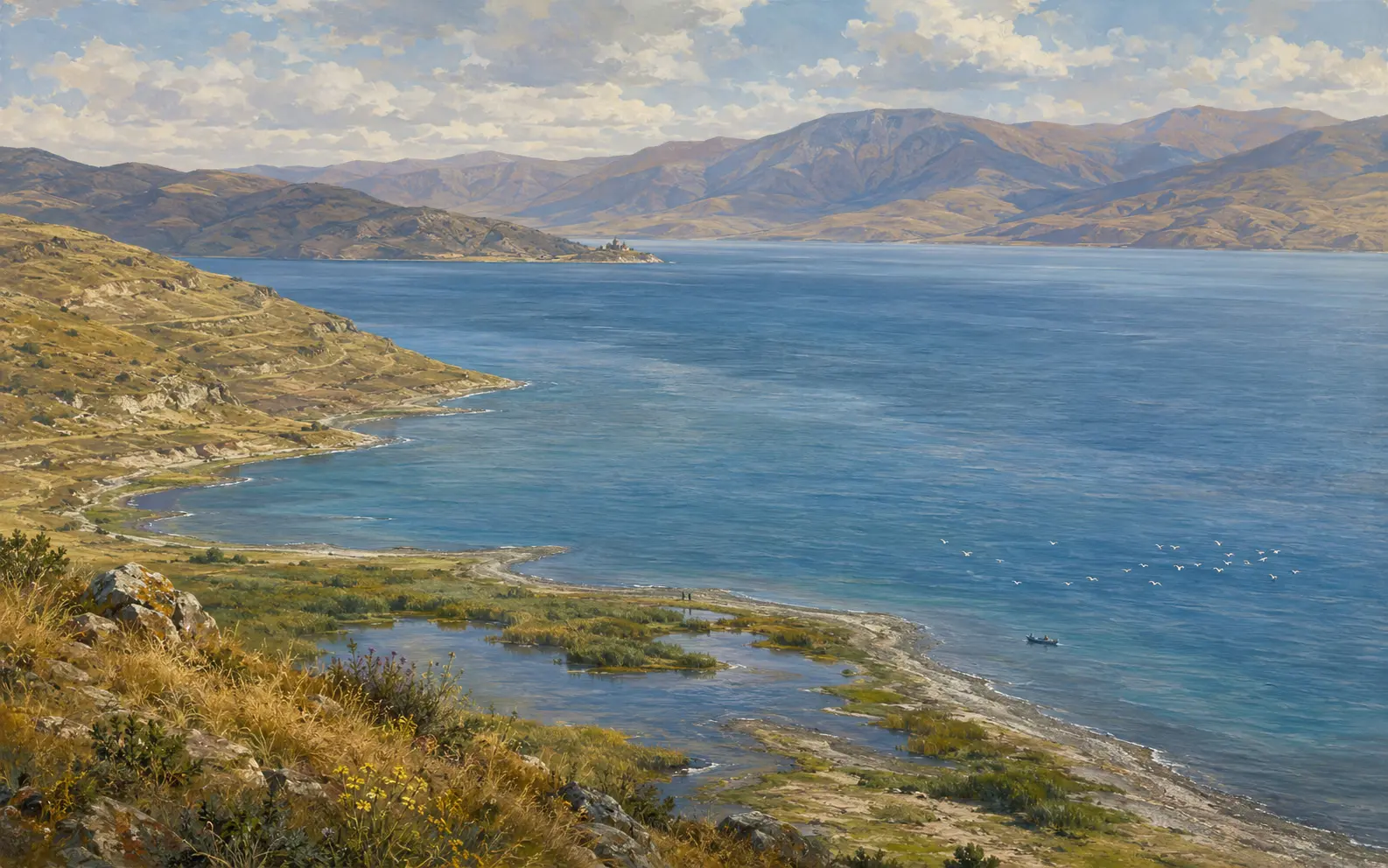
Lake Sevan lies in a high basin in eastern Armenia, ringed by mountains on every side. It is so big that Armenian usually calls it a sea rather than a lake. Its surface sits at about 1900 metres above sea level, which makes it one of the largest high-altitude freshwater lakes in the world and the dominant physical feature of the country. Yet that figure is the one thing about Sevan that is not fixed. Before the twentieth century the water stood at roughly 1916 metres. Almost everything a visitor now sees on the shore, from the causeway to the monastery to the drowned and undrowned tree stumps and the width of the beaches, comes from the gap between those two numbers. Sevan is a natural lake with a designed water level, and that is the first thing to keep in mind here.
- Author
- Armat Editorial Team
- Updated
- Reading time
- 18 min read
In brief
Lake Sevan is the largest body of water in Armenia and one of the largest high-altitude freshwater lakes anywhere. It fills a closed basin in Gegharkunik province at about 1900 metres above sea level, and that height is the heart of its story. Before the twentieth century the surface stood near 1916 metres. A Soviet engineering programme begun in 1933 then drained the lake on purpose to run turbines and irrigate the plain below. The water dropped by roughly nineteen metres, and the island monastery of Sevanavank became a peninsula. Diversion tunnels have since brought water back, the first of them from the Arpa in 1981, and the level has risen by a few metres. The lake a visitor sees is an engineered one.
Key facts
- Kind of place
- High-altitude freshwater lake, national park and river basin
- Where
- Gegharkunik province, eastern Armenia
- Surface level
- About 1900 metres above sea level — a managed figure, not a fixed one
- Water in and out
- Fed by some 28 rivers and streams; drained by the Hrazdan alone
- Protection
- Sevan National Park since 1978; Ramsar Wetland of International Importance since 1993
- The fish it is known for
- The endemic ishkhan trout, alongside introduced whitefish and crayfish
Where Lake Sevan is
Lake Sevan fills most of Gegharkunik province in the east of Armenia, about an hour's drive from Yerevan over the pass at Sevan town. It is the largest lake in the Armenian Highland and the largest body of fresh water in the Caucasus. In a country the size of Armenia it cannot be treated as a merely regional feature: it holds the great majority of the republic's surface fresh water, and its basin covers roughly a sixth of the national territory.
The surface stands at about 1900 metres above sea level, higher than most of the summits of the Carpathians or the Scottish Highlands, and that altitude shapes everything else about the lake. The water is cold and the growing season around it is short. The air is thin and clear enough for the lake to change colour hour by hour. In winter the whole basin freezes hard, although the deep water of the open lake normally does not.
The figure to remember is that before the drawdown the surface was near 1916 metres, and any map printed before the middle of the twentieth century draws the shoreline at that higher line. Old maps, photographs and descriptions of the lake therefore show a different coastline from the one visitors stand on today. Much of the confusion about Sevan comes from comparing the two as if they were the same.
The basin and the mountains around it
Sevan sits in a tectonic hollow closed on every side by mountains: the Areguni and Sevan ranges to the north-east, the Vardenis range to the south and the Gegham range to the west. The basin is a true bowl, and that is why the lake exists at all. Water collects in a depression with only one low outlet, at an altitude where evaporation alone would not empty it.
The lake is usually described in two parts, and they behave very differently. Small Sevan, the northern and north-western arm, is narrow and deep, reaching down about eighty metres. Great Sevan, the much larger southern and eastern body, is broad and shallow. Great Sevan holds most of the lake's surface and, although it is shallower, most of its water as well; Small Sevan's share of the water is much larger than its share of the surface. So a fall in level strips far more area from Great Sevan than from Small Sevan, which is why the drawdown redrew the map of the lake so drastically at its southern end.
Around the shore the land rises through pasture and rough grassland to volcanic uplands, and people have always settled along the water. The towns of Sevan, Gavar, Martuni and Vardenis sit on or near the shore, and fields farmed for centuries lie on the shelf between the mountains and the lake. This is a settled farming landscape, not a wilderness, and that is worth remembering when the lake is described, correctly, as a national park.
How the water moves
Twenty-eight rivers and streams flow into Lake Sevan, and exactly one flows out. The inflows are short mountain rivers draining the ranges around the basin, among them the Argichi, the Vardenis, the Martuni and the Astghadzor, each named after or sharing a name with the settlement at its mouth. None of them is large by the standards of a continental river. The single outflow is the Hrazdan, which leaves at the north-western corner, runs down past Yerevan and joins the Araks.
The numbers behind this arrangement are the key to the lake's whole history, and they are surprising. Only about a tenth of the water that reaches Sevan leaves down the Hrazdan. The other nine tenths go straight up, evaporating from a very large surface in thin, dry, sunlit mountain air. So Sevan is not a river with a wide place in it. It loses water mostly to the atmosphere, and its level is set by the balance between what the mountains deliver and what the sky takes.
That balance is also what made the lake look like waste to a certain kind of engineer. Water evaporating from a high lake does no work and irrigates nothing on its way. The whole twentieth-century programme described below grew from one observation: if the outlet were enlarged and the surface reduced, the same rainfall could turn turbines and water fields instead of vanishing into the air. The sums were right. The consequences went far beyond the sums.
What lives in it
The fish Sevan is known for is the ishkhan, the Sevan trout. Its Armenian name means prince, and the scientific name, Salmo ischchan, is taken from it. It is found naturally in this lake and nowhere else on earth. It was never a single uniform fish but a set of distinct forms that spawned in different places and at different seasons: some ran up the inflowing rivers to breed, while others spawned on gravel beds in the lake itself. That split is why the trout's story is not a simple one.
Lowering the lake hit each form separately and unequally. The falling water exposed the gravel spawning grounds of the lake-spawning forms, and left the river mouths used by the river-spawning ones stranded above the new shoreline or dried out altogether. A fish that breeds in one narrow band of habitat has nowhere to go when that band disappears. The summer and winter forms of the ishkhan are now variously extinct, presumed extinct, or surviving only through hatchery work, and popular accounts are often too confident about the status of each form.
Other fish were brought in on purpose, mostly to replace what was being lost, and they changed the lake in their own right. Sevan whitefish, brought from Lake Ladoga, did so well that for a time they dominated the commercial catch. Crayfish were introduced and spread widely, and carp and goldfish arrived as well. An introduced species that thrives does not repair the damage. It is a second, separate change on top of the first.
Beyond the fish, the lake and its wetlands are a stopover and breeding ground for large numbers of birds, including the Armenian gull, which breeds in great colonies on the islands and shallows. It was this wetland role, not the scenery, that the Ramsar Convention recognised when it listed the lake. The designation is about the ecological work a place does, not about how it looks from the road.
People and the lake
The basin has been inhabited for as long as anywhere in the highland, for the same reason it impresses people today: a large, permanent body of water in high, dry country, with pasture around it and passes leading out in several directions. Bronze Age settlements and burial sites ring the lake. The cyclopean fortresses on the heights above the shore belong to a long local building tradition that began well before any state we can name held the basin.
The kingdom of Urartu reached the Sevan basin from its centre far to the south-west, and left the clearest early evidence of who was here: royal cuneiform inscriptions recording campaigns and construction in this district. Urartu was a Lake Van power, and the difference matters. Sevan was territory it conquered and garrisoned, not the heartland it grew from, and mixing up the two lakes is the most common error in early Armenian geography.
In the historical geography of Armenia, most of the basin belonged to the province of Siwnik', in its northern districts of Gegharkunik and Sotk. The modern province still carries the name Gegharkunik. It was frontier country in the medieval centuries and was fought over again and again. The lake was useful in the way an island is useful: a place to put things that must not be taken. Treasuries, relics and people were moved onto the water when the land around it was unsafe.
The lake also fed people, under arrangements that were themselves old. Custom and the monasteries regulated fishing rights, seasonal catches and the trout runs up the rivers long before any ministry did. When the fishery collapsed in the twentieth century, people felt it as the loss of a livelihood with a very long history, not merely as an ecological statistic.
What stands on the shore
The building everyone photographs is Sevanavank, on the peninsula at the north-western end of the lake. The princess Mariam founded it in 874. Its two surviving churches stand on a rock that was an island for more than a thousand years, reached by boat and chosen precisely because it was hard to reach. Their position at the top of a flight of steps above the water is the most reproduced view in Armenia.
The island became a peninsula because the water fell. The strip of land visitors now walk across did not exist when the monastery was built, or at any point in its working life. This is not a geological curiosity but a direct result of the drawdown described below. The monastery did not move; the lake did, and left it joined to the shore.
Sevanavank is the best-known monument by the water, but not the only one. Hayravank stands on the western shore, and at Noratus, a little inland, lies the largest surviving field of khachkars (Armenian cross-stones) anywhere: a cemetery of carved stelae gathered over centuries. Several of these foundations were endowed and built under the Bagratid kingdom, the political setting that explains the monastic building around the lake. Their survival owes a good deal to the same remoteness that made the basin easy to defend.
The plan to lower it
The idea of draining Lake Sevan is older than the Soviet Union, and it began as an argument about waste. In 1910 the engineer Soukias Manasserian published a proposal built on the evaporation figures. Most of the lake's water, he argued, was being lost to the air. If the surface were reduced, the water saved could irrigate the Ararat plain and generate power on its way down the Hrazdan. He proposed lowering the lake by some fifty metres, leaving only the deep northern part.
His reasoning deserves a fair hearing. Manasserian was not proposing vandalism. He wanted to turn a loss into a resource, in a poor and largely agricultural country where irrigation water limited how many people the land could feed. The scheme added up, and on its own terms it was persuasive. What it lacked was any sense of the lake as more than a reservoir with a leak in the roof.
The Soviet government took up the idea and began acting on it in 1933, when work started on deepening the outlet so that more water could be drawn off down the Hrazdan. A cascade of hydroelectric stations was planned along the river below, each using the same water in turn, and the irrigation network of the plain was designed around the expected flow. In the planning documents, the lake was an input.
The full scheme was never carried out, and this matters: the lake as it exists is the product of a plan stopped part-way. The fifty metres of the original proposal would have removed almost all of Great Sevan and left something closer to a deep alpine pool. Only a fraction of that was achieved, and even the fraction changed the lake for good.
What the lowering did
The outlet tunnel was inaugurated in 1949, and from then on the level fell fast, by more than a metre a year at the peak of the drawdown. Anyone who has watched a reservoir drop in a dry summer has seen the effect in miniature. Here it went on year after year, and the shoreline retreated across the shallow southern flats fast enough to redraw the map of the district.
By the early 1960s the surface had dropped about fourteen metres, and the plan was changed from lowering the lake to holding it. The fall slowed but did not stop: the level reached its lowest point, about 1896 metres, only in the early 2000s, roughly nineteen metres below where it had started. The effects reached well beyond the water's edge. The exposed lake bed, tens of thousands of hectares of it, proved to be poor, dusty ground that neither farmed well nor grew back quickly, and it became a source of dust storms. Water quality worsened as the volume shrank. A smaller, warmer, shallower lake concentrated its nutrients, and the deep water began to suffer from oxygen depletion and algal blooms that had never troubled it before.
The fishery collapsed, and the trout suffered most, for the reason given above: its spawning grounds were the first thing the falling water removed. Sevanavank stopped being an island. Trees that had been planted or had grown at the old waterline were left stranded, and drowned stumps reappeared. Almost every visual oddity along today's shoreline dates from this period.
When Rafael Hovanesian and Harry Bronozian published their assessment of the restoration problem in 1994, the picture was clear and bleak. The engineering had delivered real irrigation and real electricity, but it had also left a degraded lake that would take far longer to repair than it had taken to damage. Their paper shows where the debate stood in the mid-nineteen-nineties, and it is cited here for that, not as a current account.
Bringing the water back
The rescue was itself an engineering project, and that is the irony at the centre of this story: the same instincts that lowered the lake were turned to raising it. Instead of simply taking less water out, the chosen solution was to bring more in from outside the basin, boring tunnels through the mountains to divert other rivers into Sevan.
The first was the Arpa–Sevan tunnel, driven for tens of kilometres under the Vardenis range to carry the waters of the Arpa north into the lake. It came into operation in 1981. Its effect was real but modest against the scale of the loss: a rise of a metre or so. That is the most telling fact in the whole story. A tunnel of that length and cost won back only a small fraction of what an enlarged outlet had let out.
A second diversion, from the Vorotan into the Arpa and on into Sevan, was begun to add to the flow. It was inaugurated in 2004 after long delays, and since then its operation has been interrupted by repairs. Meanwhile the legal footing changed. Independent Armenia passed laws specifically for the lake, and in 2001 a Law on Lake Sevan set a target level and required annual programmes of the measures needed to reach it.
The level has risen by several metres since its lowest point, and the rise has brought problems of its own, which accounts that treat restoration as purely good rarely mention. Water returning over ground that had been dry for decades has flooded roads, shoreline construction, buried infrastructure and stands of trees planted on the exposed bed. Drowned vegetation rotting in the shallows has in turn affected water quality. Putting a lake back is not the same as never having taken it away.
What to understand before seeing it
First, the shoreline is not permanent and should not be read as if it were. The lake is monitored by satellite for exactly this reason: a coast that must be re-surveyed as the water rises is a different kind of thing from a coastline on an old map. A beach, a jetty or a lakeside building may be only a few decades old, and may be underwater again within a generation.
Second, the causeway to Sevanavank. When you walk out to the monastery on dry land, you are walking across the evidence. That ground is exposed lake bed, and the view from the steps that appears in every photograph of Armenia is one that nobody saw for the first thousand years of the building's life. Nowhere is it easier to see what the drawdown did.
Third, the resort strip along the north-western shore is not the lake. Sevan is a working national park, a fishery under restoration, the country's main store of surface fresh water and a piece of contested engineering history. The beaches near the highway are the smallest and newest part of it. Most of the lake lies along the stretches of shore where none of that is on show.
Important dates
874
The princess Mariam founds the monastery of Sevanavank on the island at the north-western end of the lake, reached only by boat.
1910
Soukias Manasserian publishes the proposal to lower the lake, arguing that the water evaporating from its surface should instead irrigate the plain and generate power.
1933
Work begins on enlarging the outlet into the Hrazdan, and the Soviet plan to lower the lake starts to be carried out.
1949
The outlet tunnel is inaugurated and the level begins to fall by more than a metre a year.
1963
Work begins on the Arpa–Sevan tunnel as the plan turns from lowering the lake to holding it. The surface has already fallen about fourteen metres, and the fishery is failing. The level goes on falling, more slowly, until the early 2000s.
1978
Sevan National Park is established, bringing the lake and the land around it under a single system of protection.
1981
The Arpa–Sevan tunnel comes into operation, diverting water from outside the basin into the lake for the first time.
1993
The lake and its basin are designated a Wetland of International Importance under the Ramsar Convention.
2001
Independent Armenia adopts the Law on Lake Sevan, setting a target level and requiring annual restoration programmes.
2004
The Vorotan–Arpa diversion is inaugurated, a second transfer of water into the basin from outside it.
Why Lake Sevan matters
Sevan is the largest natural feature in Armenia and holds the great majority of its surface fresh water, so what happens to the lake is a question about the country's water, power and food, not just its scenery. It is also one of the clearest cases anywhere of a national resource being spent on purpose. The drawdown was no accident, leak or foreign imposition. It was a decision, taken on stated grounds and carried out over decades, and then reversed at greater cost than it saved.
That makes the lake unusually useful to think with. At a scale a visitor can walk across, it shows what it means to treat a living system as an input to a plan. The tunnels driven to refill it and the laws written to protect it show what it costs to change that judgement afterwards. The shoreline records the whole argument on the ground.
Interesting facts
- 01The monastery of Sevanavank was founded in 874 on an island. The causeway visitors now walk across is exposed lake bed, and the building has stood on a peninsula only since the twentieth century.
- 02The plan to drain the lake was published in 1910, before the Soviet Union existed. It proposed lowering the water by some fifty metres, several times what was eventually done.
- 03About 28 rivers and streams flow into Lake Sevan and only one, the Hrazdan, flows out. Roughly nine tenths of the incoming water leaves by evaporation instead.
- 04The surface lies at about 1900 metres above sea level, higher than any summit in Britain, and the lake is one of the largest high-altitude freshwater bodies in the world.
- 05The endemic ishkhan trout bred as several distinct forms that spawned in different places and seasons, so lowering the water damaged each of them separately instead of all at once.
Sources
- Lake Sevan — "Sevan" National Park SNCO — Ministry of Environment of the Republic of Armenia, Yerevan Visit sourceThe management body's own description of the lake it administers. Cited for the physical figures and their framing — surface elevation, present and historical area, volume and depth, the basin, the twenty-eight inflowing rivers, the Hrazdan as the only outflow, the proportion of water lost to evaporation, and the extent of the twentieth-century drawdown.
- Lake Sevan — Ramsar Site no. 620 — Ramsar Sites Information Service, Convention on Wetlands, designated 1993 Visit sourceCited only for the designation itself: the lake and its basin were listed as a Wetland of International Importance in June 1993. The Convention registers wetlands for their ecological function, which is a different kind of recognition from the World Heritage listing cited for Etchmiadzin or the Memory of the World inscription cited for the Matenadaran.
- Rafael Hovanesian and Harry Bronozian. Restoration and Management of Lake Sevan in Armenia: Problems and Prospects — Lake and Reservoir Management 9(1), 178–182, North American Lake Management Society, 1994 Visit sourceA contemporary account of the engineering programme and of what it had by then produced. Cited for the sequence of interventions — the outlet tunnel, the Sevan–Hrazdan cascade, the Arpa–Sevan diversion — and for the state of the restoration argument in the mid-1990s. Dated in the article rather than quoted as current, because a 1994 assessment of a continuing problem is evidence about 1994.
- Nelli Barseghyan, Tigran Vardanyan, Marine Dallakyan, Liana Poghosyan, Satenik Galstyan, Roza Barseghyan and Vardan Asatryan. Unveiling Priority Actions and Opportunities for the Restoration of Endemic Trout (Salmo ischchan Kessler, 1877) in Lake Sevan — Hydrobiology 5(2), article 9, MDPI — Scientific Center of Zoology and Hydroecology, National Academy of Sciences of Armenia, 2026 Visit sourceThe whole of what this article says about fish rests here: the endemic trout and its historical forms, the loss of spawning grounds as the level fell, the introduced whitefish and crayfish, and the restoration work now attempted. Cited rather than paraphrased loosely because the status of each form is precisely the thing that gets stated too confidently elsewhere.
- Martin A. Stapanian. QuickBird satellite imagery as a tool for restoration and rehabilitation of Lake Sevan, Armenia — Hydrobiologia 661(1), 81–83, Springer, 2010 Visit sourceCited for one claim only, and a telling one: the shoreline of this lake is monitored from orbit because it is not fixed. A coast that has to be re-surveyed as the water rises is a different object from the coastline on an old map.
- Robert H. Hewsen. Armenia: A Historical Atlas — University of Chicago Press, 2001 ISBN 9780226332284Already registered for three other articles. Cited here for the lake's position within the Armenian Highland and for the historical geography of the basin — the districts around it, and the routes that made a high closed basin worth settling.
Related articles
Urartu: the Kingdom of Van
Urartu was a powerful highland kingdom around Lake Van whose fortresses, canals and cuneiform records shaped the later history of the Armenian Highlands.
Bagratid Armenia and the City of Ani
The Bagratid kings restored Armenian statehood after two centuries of foreign rule and built Ani into one of the great cities of the medieval world.
Jermuk
A spa town on a high plateau in Vayots Dzor, built in the twentieth century around thermal mineral springs in the gorge of the Arpa. Its name is simply the ordinary Armenian word for a warm spring.